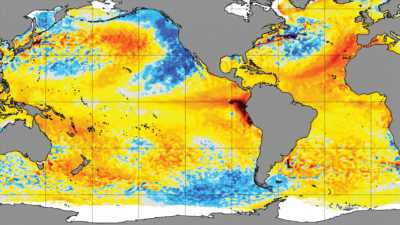
In autumn, sea temperatures fall. Not this year

Save articles for later
Add articles to your saved list and come back to them any time.
On April 1 this year the world passed a foreboding milestone when the global average sea surface temperature hit a record high of 21.1°C, beating the previous record of 21 degrees set in March 2016.
Both these records are just over a degree hotter than the average sea surface temperature in the period between 1982 and 2011.
But it was not just the high temperatures that concerned scientists around the world as the data kept coming in over recent weeks.
It was the timing of the records in the season and the fact that these were not just spikes, but that sea surface temperatures were remaining so abnormally high for so long.
A map showing the surface temperatures of the world’s oceans over recent weeks has carried a broad red stain revealing that the Pacific is unusually warm, with a menacing blob of the deepest colour lurking off the coast of Ecuador and Peru.
This is a sign that trade winds that blow from east to west across the Pacific from the Americas, and which are particularly strong during a La Nina phase, were beginning to dissipate.
Under the force of these La Nina winds, the warmed water of the surface of the Pacific eventually hits Australia, Papua New Guinea and Asia and is then forced into the depths of the world’s largest ocean.
This can cause droughts and high temperatures in North America and floods and cool weather in Australia, but globally its impact is profound.
So vast is the Pacific and so much heat does it store, that the process lowers the average temperature of the entire planet, just as El Ninos warm it.
The fact that trade winds appear to have slackened suggests that we might be shifting into an El Nino phase, perhaps a powerful one. These signals have already caused emergency chiefs in Australia to warn governments to prepare for a potentially savage fire season ahead.
But as the southern autumn began this year, scientists, oceanographers and climatologists around the world noticed something else emerging in their data that alarmed them even more.
Because the Pacific is so large and critical in shaping global weather, normally when our autumn begins, global sea surface temperatures begin to fall.
This year they did not.
By the start of May, a month after that record was set, the average temperature had finally begun to dip, but remained half a degree hotter than the long-term average.
“This is climate change happening before our very eyes,” says one of the world’s leading experts on the interplay between the southern oceans and the world’s climate, Professor Matthew England of the University of New South Wales.
He fears that much of the global heating that has taken place over the past three years due to continued carbon emissions has been masked by the impact of the rare “triple dip” La Nina. With that weather pattern stripped away, we may be seeing the true underlying impact of those years of warming.
Michael McPhaden, an oceanographer at the National Oceanic and Atmospheric Administration (NOAA) Pacific Marine Environmental Laboratory in Seattle, shares his concern.
“Even though greenhouse gas concentrations in 2022 were the highest ever, it was not the warmest year on record” in terms of global surface temperatures,” McPhaden told the news outlet Live Science.
“2016 was the warmest year on record, and that’s because we had this high burden of greenhouse gas in the atmosphere plus a major El Nino. The combination shot the global surface temps into record territory.”
Warmer seas generate more intense storms and El Nino is likely to cause hot, dry conditions in Australia.Credit: Coral Expeditions
Should an intense El Nino develop on top of the heat extra heat absorbed by the planet’s climate systems since 2016, new record temperatures could be even higher again, driving the world deeper into uncharted territory.
Scientists are still unsure of the implications, though it is clear that warmer seas generate more intense storms, and that an El Nino is likely to cause hot, dry conditions to Australia and rains to the US West Coast, which is now finally seeing some relief from years of drought.
“This is an unusual pattern. This is an extreme event at a global scale” in areas that don’t fit with merely an El Nino, Princeton University climate scientist Gabe Vecchi told the Associated Press. “That is a huge, huge signal. I think it’s going to take some level of effort to understand it.”
He noted that along with the heat patch off the South American coast [consistent with an emerging El Nino] there were marine heatwaves or ocean warming spots that don’t fit an El Nino pattern, such as those in the northern Pacific near Alaska and off the coast of Spain.
“People might dismiss these records as a few tenths of a degree,” says England, “but if you consider that the earth’s surface is 75 per cent ocean, to warm it up to that sort of record levels is very impressive.”
England calls the El Nino the world’s “heat removal service”. He doesn’t know exactly what to expect in its absence.
Get to the heart of what’s happening with climate change and the environment. Our fortnightly Environment newsletter brings you the news, the issues and the solutions. Sign up here.
Most Viewed in Environment
From our partners
Source: Read Full Article
