Britain 'hotter than Barcelona next week' – but only after more rain
Get the sun hat ready – but don’t pack away the winter coat just yet… Britain could be hotter than Barcelona next week with balmy 21C highs – but only after miserable weather today and tomorrow with yellow wind and rain warnings in place
- An Atlantic low-pressure system is moving slowly eastwards across the UK
- This is bringing strong winds, low temperatures and heavy rain or showers
Britain could be hotter than Barcelona next week with balmy highs of 21C – but only after miserable weather today and tomorrow.
An Atlantic low-pressure system moving slowly eastwards across the UK is bringing strong winds, low temperatures and heavy rain or showers to many places.
Yellow wind and rain warnings are in place across the north-west this evening, with commuters returning home from work advised to take extra care, while there is also the possibility of large waves in coastal areas and even snow over higher ground in the north.
The Met Office warns of delays to road, rail, air and ferry transport, with some journeys taking longer than usual and temperatures dropping to just 3C.
Heading into tomorrow, many parts of the country will experience strong winds, with gales in coastal areas by the afternoon.

A man takes his dogs for a walk in the rain on a street earlier today


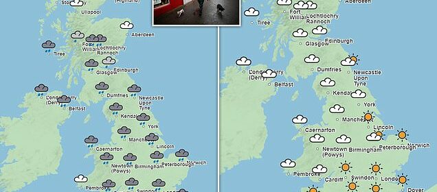
A Met Office chart shows how there will be widespread rain across Britain this evening, heading into tomorrow

However, the start of next week should see Britons able to shake off the miserable weather of recent times and enjoy a spell of sunshine

More rain is expected tonight and tomorrow following downpours on Monday (pictured)
Forecasters add that rain and showers will be isolated initially, before becoming more frequent and persistent, with hail and thunder possible at times as the day progresses.
Met Office Chief Meteorologist, Matthew Lehnert, said: ‘A low pressure system will bring a period of wet and windy weather today and tomorrow.
‘Thick cloud and heavy rain will continue to push in from west bringing 50 to 60 mph winds along western coasts. Snow is likely to fall over parts of upland Scotland overnight.
‘Some disruption due to strong winds is likely on Wednesday, especially in southern and western areas, as well as the potential for heavy rainfall and even some snow, though the latter probably confined to high ground in the north.
‘It will be another cool day with temperatures of 7 to 10 C in the west, with 11 to 13 C possible in the southeast, however it will feel colder in the strong winds.’
The weather is likely to stay unsettled through the rest of the week, Mr Lehnert adds, with sunshine and heavy showers for many on Thursday, and persistent rain in the south on Friday.
However, the start of next week should see Britons able to shake off the miserable weather of recent times and enjoy a spell of sunshine.
The Met Office predicts the mercury could even rise to 21C by next Tuesday – making the UK hotter than popular European destinations such as Barcelona, Athens and Rome.
Its long range forecast says: ‘A ridge of high pressure is likely to develop, resulting in fine and dry conditions for many, with breaks in the cloud likely.
‘These settled conditions are expected to continue later in the period, with frequent dry weather for most, perhaps with the odd shower.’
Jim Dale, senior meteorologist at British Weather Services, added: ‘Sunshine and rising temperatures through next week widespread 17C to 21C is on the cards.’
Source: Read Full Article