The summer ahead of worry was set up in September
The city of Melbourne sat as a moody, dry island for much of Thursday, lulling citizens of the state capital into a false sense of security. Those who set off for regional areas, however, learnt quickly what was coming.
Out there, in riverside towns and low-lying farming regions, urgent evacuation orders were being issued, residents were struggling to sandbag their homes, businesses and graziers were trying to move livestock to higher ground and the State Emergency Service was reacting to what would become hundreds and then thousands of cries for help.
To merely drive south-west to Geelong, east to Gippsland, west to Ballarat or north anywhere along the Calder or Hume highways meant confronting walls of blinding rain, risking aquaplaning on sheets of water and dodging potholes opening up on every road.
The Bureau of Meteorology’s radar imagery revealed a giant blue doughnut of solid rainfall surrounding a weirdly dry Melbourne and bulging across much of the state.
Beyond Geelong, for instance, you needed to travel almost to Warrnambool, 270 kilometres from Melbourne, straining for sight of the road almost all the way, before a clear sky could be seen. This reporter did precisely that, and has no desire to repeat the experience.
By Thursday evening, however, the sodden doughnut closed on the Victorian capital and a state flooding disaster, long in the making, was complete.
Victoria knows about disasters. It is the most bushfire-prone area in the world. But compared with states like Queensland and NSW, flooding isn’t high on Victoria’s catalogue of calamities.
Who in Victoria did not look at news coverage of recent inundations of entire valleys and thousands of homes in NSW and breathe a secret sigh of relief that we lived in places unlikely to be visited by such horror?
Apart from localised deluges, the last big Victorian flood was in 2011. Like 2022, it was a La Niña year.
Older people can remember 1946, when bridges across south-west Victoria were swept away, five members of a single family drowned near Macarthur when their horse-drawn cart toppled off a flooded track and every fencepost that wasn’t altogether underwater had a tiger snake curled at the top.
Fewer can recall the catastrophic flood of 1934. More than 140 millimetres of rain fell over two days in Melbourne, and more than double that in Gippsland.
“From Warburton to Melbourne the Yarra has become a series of vast lakes connected by swirling rapids,” The Argus reported on December 3, 1934.
Thirty-six people died, and many thousands of people were left homeless.
On Thursday, householders along the valley of Melbourne’s other significant river, the winding Maribyrnong, went to sleep on Thursday evening content that their homes were safe.
Many of them were to learn that when the sky opens up over a river’s higher catchments, safety is not a reliable word downstream.
But to have imagined the extent of what peril might occur they would need to have consulted the record of 1906, when Footscray and Kensington were hit by a flood that measured 5.18 metres on the Maribyrnong gauge.
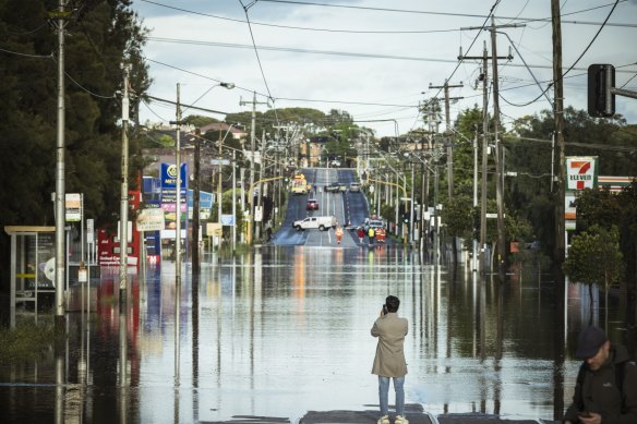
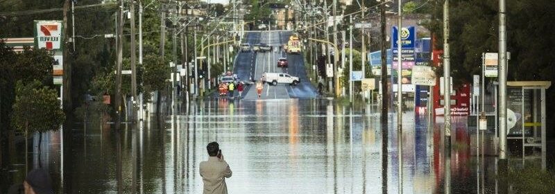
Flooded streets in Melbourne’s west after the banks of the Maribyrnong River burst.Credit:Chris Hopkins
The course of the Yarra has been altered over the years to spill its waters more readily into the sea and to reduce the risk of flooding.
By Friday afternoon, however, even residents along the Yarra – from the high reaches of the Yarra Ranges to suburbs like Kew and Balwyn and Abbotsford – were being warned to keep a close watch on their river’s rising waters.
Those living north already knew all about the meaning of emergency.
By midday Thursday at Echuca, where the swollen Goulburn and Campaspe rivers spill into the Murray – itself running hard and wide, its giant feeder dams upstream overflowing – residents were told to boil their water because stormwater had overflowed into their drinking water storage.
It was an inconvenience rather than the tribulation engulfing other towns on Victoria’s river systems, where hundreds in places like Seymour and Rochester were being rendered homeless and some towns such as Benalla were split clean in two by rising waters.
Back in Melbourne, where the Melbourne Cup carnival is scheduled to begin with the Victorian Derby on October 29 – just 14 days away – a 3.5-kilometre flood mitigation wall built early this century to protect Flemington Racecourse managed to hold back the encroaching waters spilling over the banks of the Maribyrnong.
However, a popular feeder event to the carnival, the Avoca Cup in western Victoria, scheduled for Saturday, was abandoned because of flooding.
An anxious Racing Victoria announced it will “continue to monitor forecasts and its potential impact on scheduled race meetings, with significant rainfall predicted in parts of Victoria”.
Truth is, the weather gods began setting up Victoria for its current flooding disaster months ago. The state was delivered rainfall 12 per cent above the average from January to September.
And then, during September itself, some areas of the state, from Manangatang in the far north-west to Lake Eppalock near Bendigo in central Victoria, experienced the highest rainfalls ever recorded for the month, according to the bureau.
Several other districts, in a sweep from Kyabram in the north-central down through Elmore, north of Bendigo, Redesdale east of Maryborough and Blackwood near Ballarat, copped their biggest September rains for 20 years.
Minor to moderate flooding was recorded during September in numerous catchments through northern and central areas.
Late in the month, the state’s biggest water storage, the Dartmouth Dam, full to the brim with snow melt and high country inflow, began spilling over its wall for the first time since 1996.
Most of Victoria also experienced below-average temperatures over September.
High rainfall meant the soil became sodden, unable to absorb further rainfall. The cool weather denied the land the relief of evaporation.
And, of course, it happened to be Australia’s third La Niña year in a row.
Could La Niña yet reprise the catastrophe it delivered in early 2011? That event, weather watchers would recall, was the culmination of a two-stage shock that began in September the previous year.
The disaster of January 2011 across western and central Victoria occurred on land already saturated by widespread flooding in September 2010.
It inundated more than 1730 properties in 51 communities, forced the closure of hundreds of roads, destroyed tens of thousands of hectares of crops and pasture and killed thousands of sheep.
And there, as the rainband that all but covered Victoria as a giant sodden doughnut on Thursday retreated on Friday, crouched the real worry among those who must deal with the aftermath of disaster.
Will La Nina bring follow-up flooding to Victoria? And could it be worse than this?
The Morning Edition newsletter is our guide to the day’s most important and interesting stories, analysis and insights. Sign up here.
Most Viewed in National
From our partners
Source: Read Full Article